George Lawrence's 1906 Panoramas
of Pacific Grove, California
by Peter NurkseJanuary 2011
PDF version
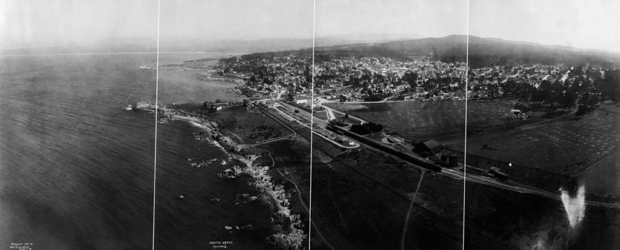
George Lawrence took two panoramas of Pacific Grove in 1906: the Library of Congress panorama, which includes ocean and shoreline and mountains and sky, shown above, and a second panorama which focuses just on central Pacific Grove. Here is a section of that second picture, annotated by the Pacific Grove Museum of Natural History:
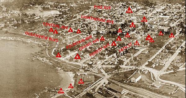
The full copy of this second panorama, with illustrated notes, is on the Museum Web site
However the comment there that it was taken from a balloon is not correct, since Lawrence abandoned balloons years before coming to California, after falling 200 ft. over the Chicago stockyards, and being caught in a windstorm over Minneapolis. He survived the fall by bouncing off some wires on the way down, but after the windstorm experience he never used balloons again.
This second panorama is more limited in scope than the Library of Congress panorama of Pacific Grove on the CD, and perhaps was taken with another camera. Lawrence took a second camera with him to California in 1906, in addition to his 50 lb. panoramic camera. The Museum panorama could have been taken with a conventional flat focal plane camera, without the panoramic wraparound effect of a curved focal plane.
The Museum panorama of Pacific Grove was taken at a steeper vertical angle, to emphasize the downtown area, like most conventional aerial photographs, a simple document. While the Library of Congress panorama of Pacific Grove resembles Lawrence’s other 1906 panoramas more closely, since like the others it shows Pacific Grove in an overall panoramic setting, as art as well as a document, including the ocean and the hills and sky behind as well, typical of Lawrence's work.
Possibly Lawrence took the Library of Congress panorama first. Since he made contact prints directly from the 4 ft. wide negative, he could have shown copies of the result quickly on the spot in Pacific Grove. And perhaps then he found some local interest in a more limited and conventional picture just of the town itself, which would explain why he took the Museum panorama, which is not his usual more ambitious style.
The Museum has keyed their copy of the panorama to individual historic pictures of buildings and places, which are equally valuable for identifying buildings and places in the Library of Congress panorama. Many of the buildings are common to both pictures.
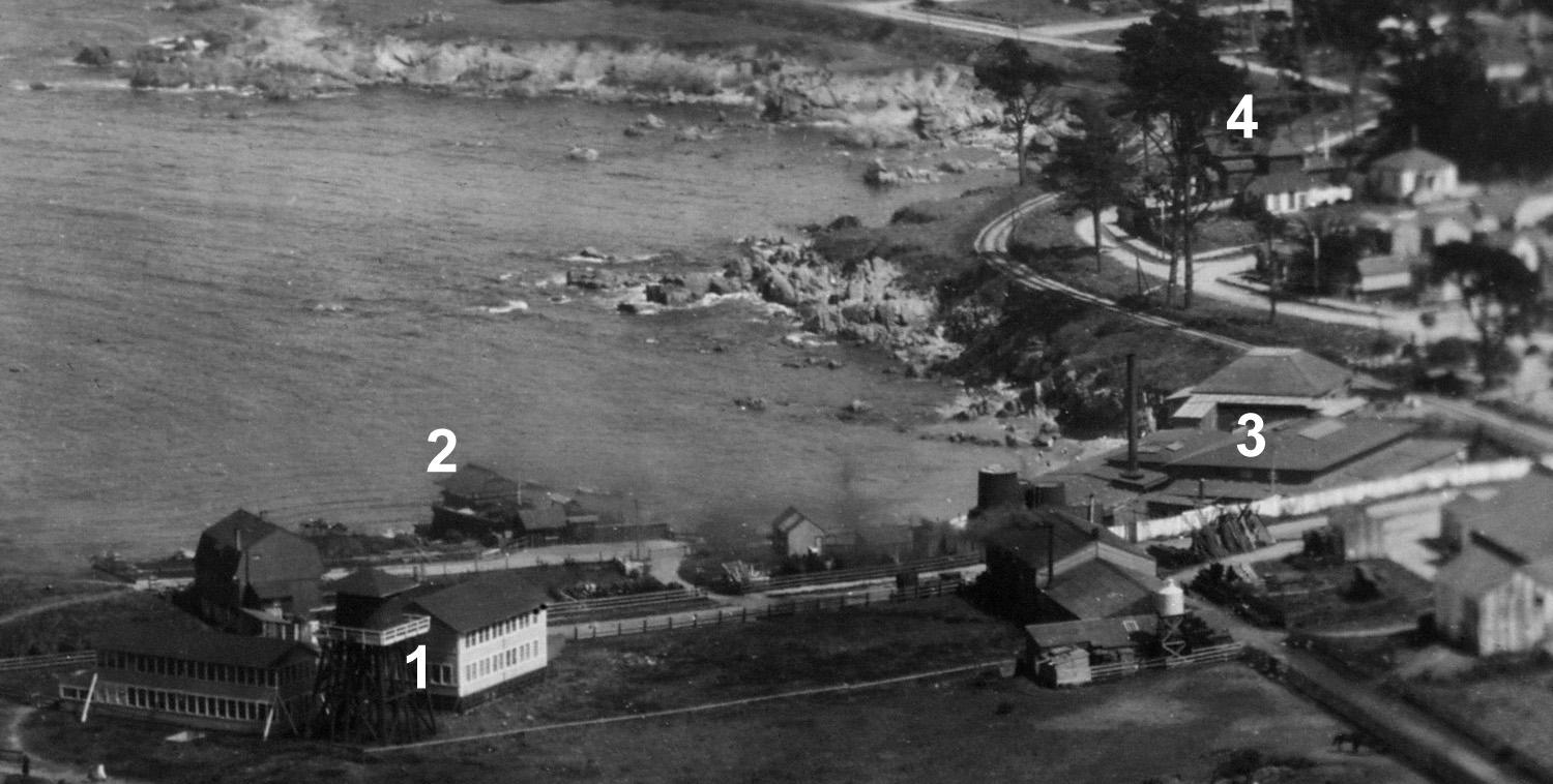
1. Hopkins Marine Lab at Lover's Point. It was later moved in 1917 to Alones Point to the east.
2. Behind the Marine Lab, on the edge of the cliff overlooking the water, is a distinctive building with a Japanese style peaked roof. This was a Japanese tea house from 1904 to 1918, a sign of increased interest in Japanese culture and art in the US and Europe at that time.
3. The Bathhouse heated sea water for indoor salt water bathing, popular here as in Santa Cruz. It included a small beach in front.
4. Seven Gables, now the Inn of Seven Gables, a bed and breakfast inn.
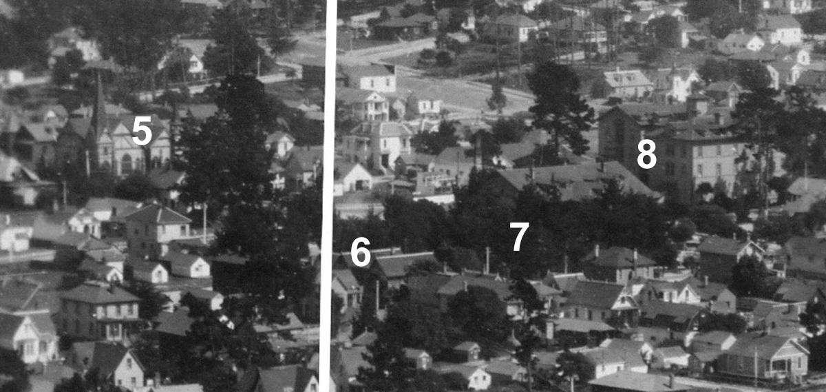
5. Mayflower Congregational Church.
6. Jewell Cottage, two peaked roofs.
7. Jewell Park.
8. El Carmelo Hotel, built in 1887 after a fire destroyed the Del Monte hotel in Monterey (the Del Monte burned to the ground again in 1924). Both the El Carmelo and the Del Monte were owned by the railroad big four, Stanford and Huntington and Crocker and Hopkins. They extended the railroad from Monterey to Pacific Grove in 1889.
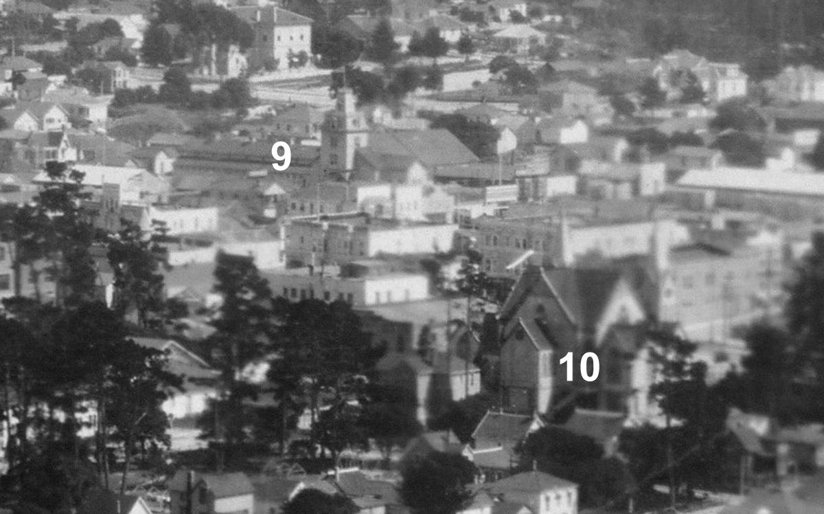
9. Mammoth Stables, a large building with a five story tower.
10. First Methodist Church, Pacific Grove was originally a Methodist settlement.
Lawrence apparently took the Museum panorama on July 10, 1906. The Library of Congress panorama was probably taken within a few days at most, since the same string of ten passenger cars is standing in the same place at the railroad station in both pictures (the seventh car back from the station end is longer than the other cars, very distinctive). Both panoramas show the hay drying in the pastures in Pacific Grove in 1906, solar powered fuel for local transportation (horses). Although only the Library of Congress panorama shows a baseball game in progress on the diamond above the station.
On the tracks to the left of the station is a single freight car on its own. Directly above that car is a large white barn building. The barn and some associated structures were built by David Jacks, a local dairyman after whom Monterey Jack cheese was named. At the time of this picture the dairy was owned by George Bodfish, and known as the Bodfish Dairy.
This dairy is the only industry of any kind visible in Pacific Grove, which was very much a residential community. Beyond Alones Point on the coast you can see a wall of trees extending inland. It seems that those trees were planted by Pacific Grove to screen out the view of Monterey, because right on the other side of the trees was the beginning of Cannery Row, with all the sights and noise and smells of large food processing plants. Today Monterey and Pacific Grove blend together very well, but not in 1906.
Cannery Row also had many Chinese immigrants. At the time of the earthquake, there was a Chinese fishing village in Pacific Grove along the coast at Alones Point. But a month after the quake, that village burned down, possibly by arson. Some Chinese refugees from San Francisco had settled in the fishing village, and perhaps certain Pacific Grove residents did not want more Chinese in Pacific Grove. After losing their homes, many of the Chinese in Pacific Grove moved over the border to Monterey, past that wall of trees, and began working in Cannery Row.
On the Monterey Peninsula, the local authority for photographic history is Pat Hathaway, who has a store featuring historic photographs, California Views, at 469 Pacific St. in Monterey (www.caviews.com). Pat has over 30,000 photographs catalogued of the Peninsula and the rest of California, and the store is well worth a visit.
Pat was able to explain that the well packed fenced road in the middle of the picture which ends in a sheer drop off above the ocean was the city garbage dump. Pacific Grove just dumped their garbage into the ocean there and the prevailing northerly currents swept it off around the Monterey peninsula, past Carmel, to unknown points further south.