Notes on the 1906 Bay Area Panoramas by George Lawrence
Peter Nurksenurkse@gmail.com
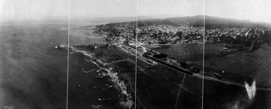
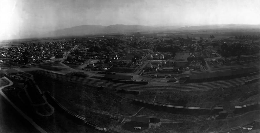
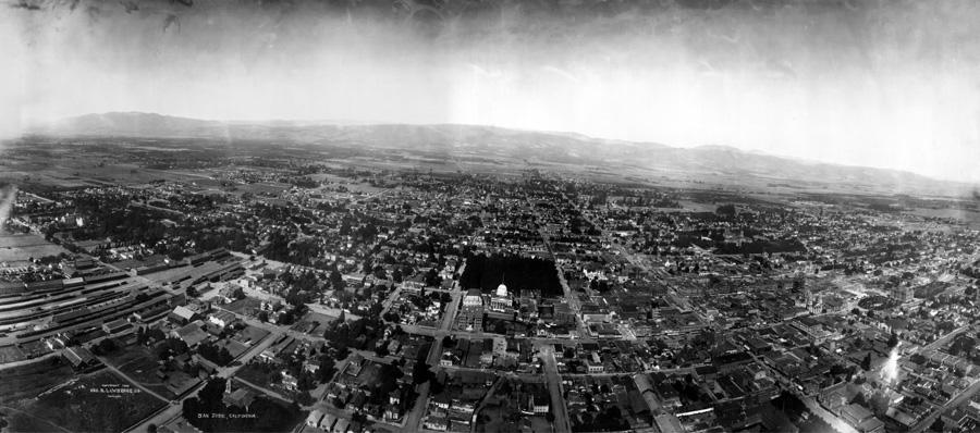
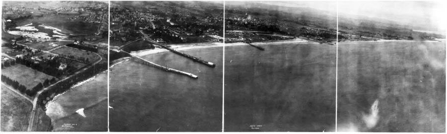
George Lawrence worked in other areas of California than San Francisco. Here I discuss his aerial panoramas of San Jose, Santa Cruz, Salinas, and Pacific Grove, all taken in 1906. The pictures here are restored black and white high resolution. In each case, the picture is probably the first aerial photograph of that city (except for San Francisco, where Lawrence took a series of panoramas, over a month).
(read more) |
 | |
(read more) |
 | |
(read more) |
 | |
(read more) |
 | |
(read more) |
 | |
Showing George Lawrence’s 1906 Bay area panoramas at full available resolution as 6 ft. wide prints I’ve seen they have the power to stop people spontaneously in their tracks, on sidewalks, and in lobbies, and in corridors, anywhere at all. People are usually not able just to pass by these pictures, they have to stop and look.
These photos are probably not simply historic documents, but they are also art, and their power to move and involve people is art at work. Art may always have more power than simple documents, and these panoramas could be an example. Anyone at all from any background can respond to them and interpret them, at any age, from school children on up. They deserve to be well known, as photographs and as art.
The Library of Congress has over 4,000 panoramic photographs available on-line, mostly from the period 1900 to 1910. George Lawrence is the leading individual contributor, with over 250 pictures. Lawrence was a leader at the time in aerial photography, and also in flash photography and large camera photography. He took one promotional picture of a railroad train with an eight ft. wide negative and a 1,400 lb. camera requiring a crew of fifteen men. That picture won him a grand prize at the 1900 Paris International Exposition, after the organizers sent the French consul in New York to Chicago to verify the picture was genuine.
For aerial panoramas, Lawrence developed his own custom 50 lb. aerial panoramic camera, with a curved focal plane holding a four ft. wide negative, lifted up into the air by a string of as many as seventeen cargo kites pulling on a steel cable. He had a crew of five men to handle the camera and the kites, and that four ft. wide negative is to this day the largest negative ever used for aerial photography.
Dr. Simon Baker has written extensively about George Lawrence and his photographic achievements, including flash photography and large camera photography, and his work is the basis for most information about Lawrence. Dr. Baker’s articles have been collected on-line by Charles Hall at: http://robroy.dyndns.info/lawrence
That page also has a link to a recent article on Lawrence by Janice Petterchak, which is the most complete biography available of Lawrence and his life.
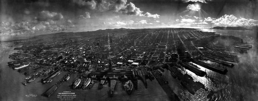
When Lawrence heard of the San Francisco earthquake of 1906, he sensed a business opportunity, and came out promptly to take a series of aerial kite panoramas of the city in May, 1906. The most famous of these pictures is his Ruins of San Francisco panorama, taken on May 28, 1906.
In April, 2006, I learned from Scott Haefner at the US Geological Survey in Menlo Park that the Library of Congress had put on-line a high resolution image of the Ruins panorama of San Francisco. After a month of email and phone calls, I discovered the Library had also placed another high resolution George Lawrence panorama on-line, of San Jose in 1906.
At that point I asked Barbara Natanson, manager of the Prints and Photographs Reading Room reference desk at the Library of Congress, for similar high resolution files of the remaining three northern California 1906 panoramas, taken by Lawrence on the same visit. It took six weeks to complete the job, since these scans were not part of the Library normal workflow. But in July the Library of Congress did place on-line high resolution scans of the 1906 Santa Cruz, Salinas, and Pacific Grove panoramas.
The images here have been cropped to removed scanner background areas, and have been restored as the original black and white photos (without the brown sepia tint fashionable in 1906) with increased contrast. In Photoshop, the black and white option is ‘Image >Mode > Greyscale’, and the restored contrast is ‘Image > Adjust > Auto Levels’. I’ve also touched up the more obvious tears and scratches and dust spots, and edited when possible cuts where the panoramas were sometimes sliced up to fit smaller file cabinets.
Anyone may have other ideas what to do with the original files, to preserve them or to restore them. They can be interpreted in many different ways, and probably with more knowledge and skill too. The original Library of Congress high resolution TIFF scan files (150MB to 250MB each in size) are available at: http://memory.loc.gov/ammem/collections/panoramic_photo
Just do a ‘Search this collection’ (on left hand side of page) for any of the city names. All the other Library of Congress historic panoramic photos can be browsed from this page by Subject, Creator, or Place, or searched by keywords.
The Library of Congress has over 4,000 century old panoramic photographs, and 1,400 even older 3D hand drawn panoramic maps or views, all catalogued and displayed online at memory.loc.gov (see under ‘Architecture, Landscapes’), the national digital collections of the Library of Congress. The photographs mostly date from the decade 1900 - 1910, when panoramic photography was new and copyright valuable for individual panoramas. The hand drawn views (called ‘Panoramic Maps’ by the Library of Congress) are generally older, from 1850 to 1900, from a period before panoramic photographs, when if you wanted a panorama you had to draw it.
In the on-line collections the Library has usually documented the panoramic photographs in a production process with a scan of the negative of a secondary roll film camera picture of the original panorama. The resulting on-line images are adequate for distinguishing the pictures, but are not the same resolution as the originals. However the hand drawn panoramic views were documented with a different process and usually scanned at full resolution, so the views can often be printed out several feet wide, like these five high resolution 1906 Bay area panorama photographs.
All the old panoramic photographs and views available on-line at the Library of Congress are now public property, according to the Library, who should know: "Works published or registered in the U.S. before Jan. 1, 1923, are now in the public domain". As public property, these images can be used for many purposes, private or public, and the Library of Congress only asks to be given credit if they are reproduced. They probably deserve to be known better and to be used widely for any purpose.