Notes on George Lawrence's 1906 Aerial Panoramas
of San Francisco
by Peter NurkseJanuary 2011
PDF version
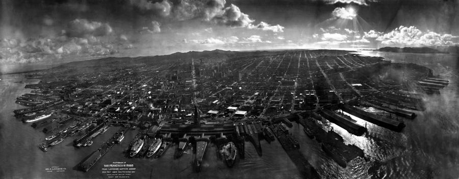
You can see many brand new buildings in this picture, even though it was taken only six weeks after the earthquake. Those are the new roofs shining in the sunlight down by the waterfront. They aren't permanent buildings, probably just temporary storehouses and warehouses for the recovery effort, to store materials and supplies.
The Ferry Building in the bottom foreground of the picture was a center for the recovery work, just as it is a landmark in San Francisco today. You can see scaffolding around the Ferry Building tower. The tower was damaged in the quake, and the scaffolding was erected afterwards for repairing it. The Ferry Building probably had a high priority, because it was so important for transportation and supplies.
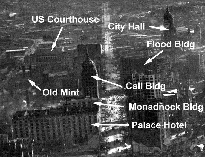
In this view up Market St. there are two Federal buildings which escaped the fire: the US Courthouse on 7th St. (rear view), and the Old Mint on 5th St. The Courthouse has been enlarged since, so the rear façade today is somewhat different. The Old Mint itself is obscured here, but the two tall brick smokestacks above it stand out, still there today. The Mint had a well inside the building, which supplied water for the night shift employees protecting it. The April 2006 issue of Smithsonian Magazine has a detailed article on how they saved the Old Mint, which is available on-line: http://www.smithsonianmagazine.com/issues/2006/april/earthquake.php
The City Hall dome is still visible in this picture, but the
entire building had to be torn down and rebuilt. The Flood Building was
stronger construction. It was burned out inside, but the structure was
sound, so the interior was rebuilt and the building is still there
today, at the corner of Market and Powell.
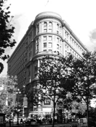
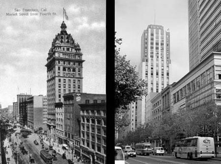
The Call Building was the tallest building in San Francisco in 1906. It too was burned out inside, but it also survived quake and fire in good structural condition, it proved itself. So it was rebuilt inside as well, and is still there today at Market and Third. In the 1930’s it was remodeled to add more floors, and got the name Central Tower, but it is the same structure that survived the quake and the fire. Call building on the left, and the remodeled building on the right:
The Palace Hotel was the biggest hotel in the world when it opened in 1876. It was standing after the fire, but was so badly damaged it had to be demolished, and the hotel there now is a new building. The rubble from the ruins of the Palace Hotel was carted across town and dumped into the Golden Gate where the Marina is now. Apartments were then built there in the Marina on top of the ruins of the Palace Hotel, and some of those apartments collapsed in the 1989 earthquake.
Right behind the Palace Hotel the uppermost story of the Monadnock Building is just visible. The Monadnock didn’t just survive quake and fire, it also survived two determined efforts by US Army demolition crews to blow it up, to create a firebreak to try and save the Palace Hotel. So of course it’s there today, at 685 Market St., definitely a strong building, while the original Palace Hotel is gone.
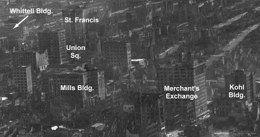
The Whittell Building survived in good shape because it was under construction, a simple steel skeleton, when the quake hit. You can see in the picture how below the roof it doesn’t appear as solid as the other buildings, more of an outline. That’s the steel skeleton. After everything had settled down, the owners just went to work and completed the building, and it’s there on Geary St. today.
Not visible in this picture is the Butler Building, right behind the Whittell Building at the corner of Geary and Stockton. It also was a steel framework under construction, and those owners just finished it off afterwards too. In later years it became an I. Magnin’s store, and is now part of Macy’s. The steel of the Whittell and the Butler buildings was actually singed by the fire, but they proved themselves.
The St. Francis Hotel was building a third wing facing Union Sq. when the quake struck. They just continued construction afterwards. The Mills Building at 220 Montgomery is the only surviving example in San Francisco of the Chicago School of architecture with the typical steel frame design. The marble staircases in the lobby needed only some minor repair after the fire. The Kohl building was the only downtown building that didn’t burn out completely inside, and it survived too.
You can see a small tower on the roof of the Merchant's Exchange, at the right near corner. Lookouts used to be stationed in the tower, and when they saw a ship entering the Bay they'd run downstairs to tell the merchants below, and the merchants then had time to walk down to the docks to get their cargos. This building was burned out, but structure was sound and it is still there today, at 365 California.
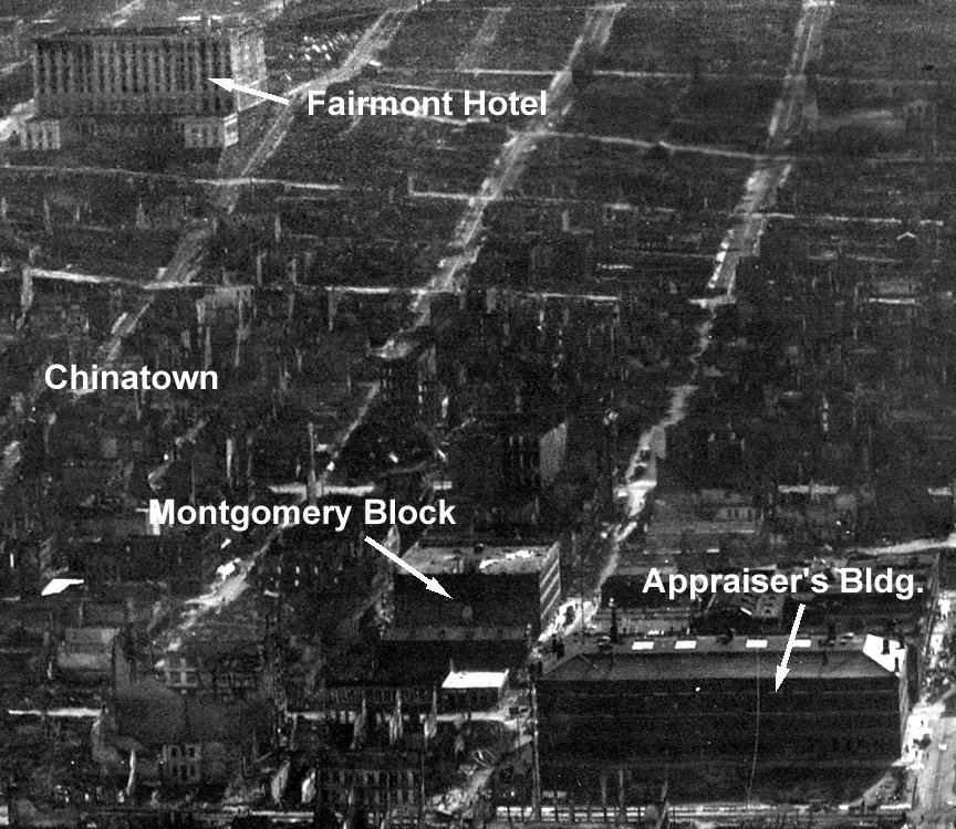
The Fairmont Hotel on Nob
Hill was brand new, and scheduled to open within a few weeks, when the
quake hit. It was burned out inside, but the structure was still good,
so they rebuilt it inside and opened it just a year later. The
Huntington and Crocker and Stanford and Hopkins mansions, on either
side of the Fairmont, were all destroyed.
Between the Fairmont and downtown was Chinatown, which can be identified by all the ruins still standing. As you can see, most residential blocks were already cleaned bare to the ground in the initial recovery effort. But ex-mayor James D. Phelan and others had formed a Committee on the Location of Chinatown, and proposed to move Chinatown down to the Hunters Point area after the quake, because the land here beneath Nob Hill was so valuable for offices and other purposes. But the Chinese residents resisted, and refused to allow their land to be cleared. After Seattle and Los Angeles offered to take in the Chinese refugees from San Francisco, with hopes of increasing their share of the China trade, the Chinatown refugees got their land back.
The Montgomery Block was the first fireproof office building in San Francisco, in 1853. It was built on the waterfront at the time, on a foundation of redwood logs since the ground was so wet. In the earliest Gold Rush years entire blocks of the new city burned down regularly, so there was interest in an office building that wasn.t built of wood. And the Montgomery Block survived the 1906 fire well, not even burned inside. In 1959 the Montgomery Block was torn down to build a parking garage, but the parking garage in turn was later demolished to build the Transamerica Pyramid, which is now on this site.
The Appraiser's Building, also known as the Customs House, was a Federal building, like the Old Mint. And Federal buildings were often constructed to higher quality and on stronger foundations than most other buildings. And the US Army led the fire fighting efforts in this area of the, and the Army was interested in saving Federal buildings if they could. So the Appraiser’s Building survived intact, and the attention to it might have helped the Montgomery Block survive too. The Appraiser’s Building was later torn down, and the current Customs House is a different building.
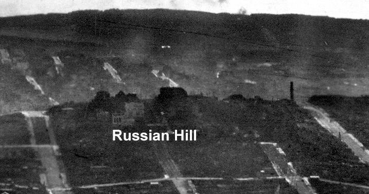
On Russian Hill a few blocks, which were surrounded by the fire on all sides, survived intact. You see the streets so clearly elsewhere in the picture simply because the buildings are all gone in those neighborhoods, and there's nothing left there but the streets.
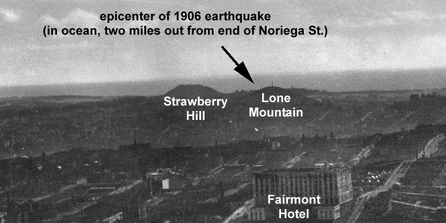
The US Geological Survey has placed the epicenter of the 1906 earthquake on the San Andreas fault under the ocean floor, two miles offshore from the end of Noriega St. in the Sunset district in San Francisco. A tidal gauge at the Presidio, the only tidal gauge in N. Calif., recorded the waves of a four inch high tsunami generated by the quake, and the patterns on the gauge chart helped locate the epicenter. That puts the epicenter only eight miles away from the center of the downtown business district. Considering that most of the damage downtown was caused by fire, the larger downtown buildings seem to have survived such a close major quake quite well.
George Lawrence took the panorama from a boat out in the bay. The camera was hanging about 2000 feet off from the end of Market St. Given that the quake epicenter was two miles out in the ocean from the end of Noriega St, here is a line of sight from the camera to the epicenter:
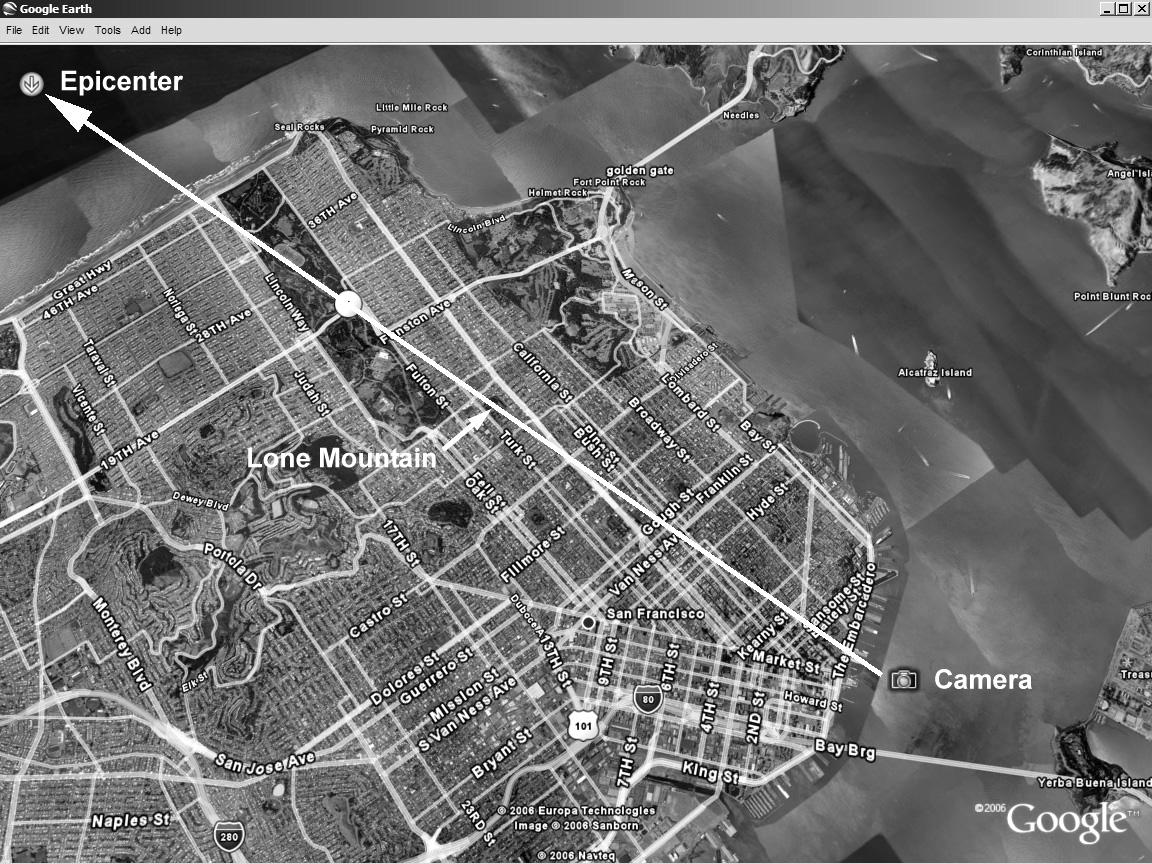
The line of sight passes directly over Lone Mountain (now the USF campus) and to the north of Strawberry Hill in Golden Gate Park. So it seems Lawrence took a picture that includes the epicenter of the 1906 earthquake, as well as the ruins. The epicenter was only fixed recently, using records of that four inch tsunami. But Lawrence can get credit for being prepared and doing his best to record the quake, and he succeeded, even including the epicenter: