Notes on George Lawrence's 1906 Aerial Panoramas
of San Jose
by Peter NurkseJanuary 2011
PDF version
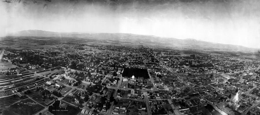
This panorama shows San Jose as a working and residential community in 1906. It doesn’t have the drama of Lawrence’s San Francisco panorama, but it tells much more about work and life a century ago. Leonard McKay, the late San Jose historian, described this picture printed full size as "beautiful" and "magnificent", an unusual historical document.
Anyone could have useful comments and insights about the picture. Not only historians and photographers, but also residents, school children, city planners, artists, builders, architects, and writers. And this picture could be valuable in another century too, it could have value after most of our current daily issues and crises are forgotten.
Much of the information in these notes comes from "San Jose’s Historic Downtown", by Lauren Gilbert and Bob Johnson, recently published in 2004 and a good pictorial guide to the places in the history of San Jose.
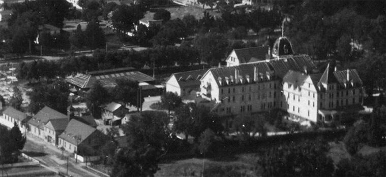
- Hotel Vendome was a destination resort of the period, and survived the quake (although an annex collapsed). The Library of Congress has posted an 1897 short film on-line of horses and carriages passing by the Hotel Vendome. Small and crude, an early film, but so like early digital video experiments of a few years ago, a reminder that the past can repeat itself again in the present.
- to the
rear of the hotel, you can see the large stables building, located as far away
as possible on the property from the guest rooms. The hotel offered a popular
seven hour coach ride to the top of Mt. Hamilton and a short pause there to
admire the view and see the observatory, followed by a four hour ride back to
the hotel. So a large stables building was appropriate, and for the guests’
horses as well.
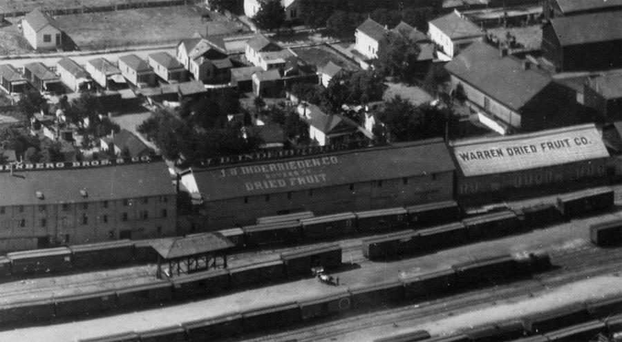
- the storage sheds in the railroad yards feature names of different dried fruit
companies on the roofs. Some roofs have the lettering traced by hand on the
negative, to make it more readable. At this time, refrigeration or local ice
sources were not available, so produce shipped longer distances was usually dried fruit.
The size of the railroad yards and the storage sheds shows the importance of
that industry.
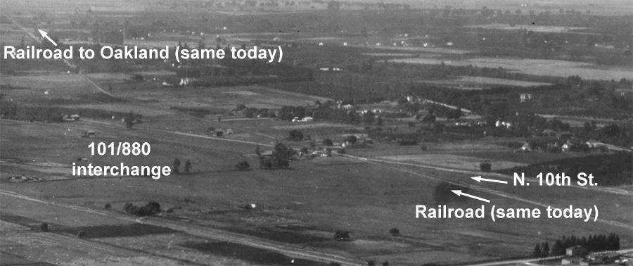
the railroad tracks lead out of town north towards Oakland and cross N. 10th St. out in the middle of open pastures. The railroad still crosses N. 10th St. today at the same point, but the open pasture on this side of that intersection is now the 101/880 interchange. If someone in 1906 had been given a vision of the future of that pasture, they might have found it difficult to understand. And after another century resolving energy problems, in the future there could be pasture there once more, the future is rarely just more of the same that we have today.
- throughout the 1906 panoramas of local cities by George Lawrence,
railroads are the most stable form of transportation, compared with today. That
suggests public investment in rail transportation may be well justified, even
if immediate returns are more difficult to find. Because in another hundred
years rail transportation may still be the most stable form of transportation,
and people then may appreciate if we invest in railroads today and keep railroads
in operation.
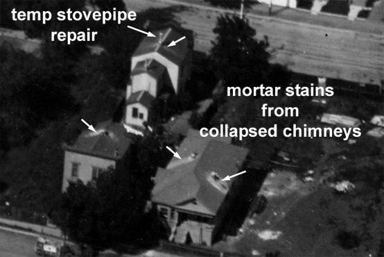
- looking down into residential neighborhoods, there are white powder marks below the chimneys on many houses. Those stains show where brick chimneys collapsed in the quake, and the same marks were visible in neighborhoods in Santa Cruz after the 1989 quake. When brick or masonry structures collapse in an earthquake, typically the bricks or stones don’t break, but usually the mortar joining them crumbles into a white powder, which then stains roofs and walls and sidewalks.
- moving over to the center of the panorama, there’s St. James Park, a large
dark block of trees, many more trees than St. James Park has today. Although
today we have more trees in residential areas, it seems over the last century
cities everywhere have reduced the density of trees in public spaces, like St.
James Park. Often with a goal to reduce crime in parks. Presumably in 1906 they
didn’t have much concern for crime in public parks, and they allowed themselves
to have more trees instead.
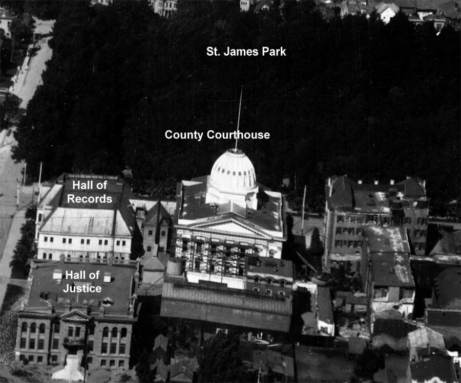
- the county courthouse is on this side of the park (entrance from N. First St., on the park side). The prominent dome was built when there was a chance San Jose might become the state capital. The dome survived the quake in good shape, but collapsed in a fire in 1931, after which the courthouse was rebuilt with an extra story. To the left of the courthouse in this view is the Hall of Records, built in Romanesque style. On this side of the Hall of Records is the brand new Hall of Justice, completed when the quake struck but not yet dedicated. You can see there was heavy damage to the left façade, and the stones fell down onto the ground between the building and the street. This building was so damaged it had to be rebuilt, and today the Superior Court building occupies the site.
- the Fallon House is a 3 story light color building, with some elegant
arches on the ground story, at the bottom of the picture. But the elegant arches
were part of a later large addition, as big as the original house, and when
the building was restored as a historical landmark this entire rear addition
was removed.
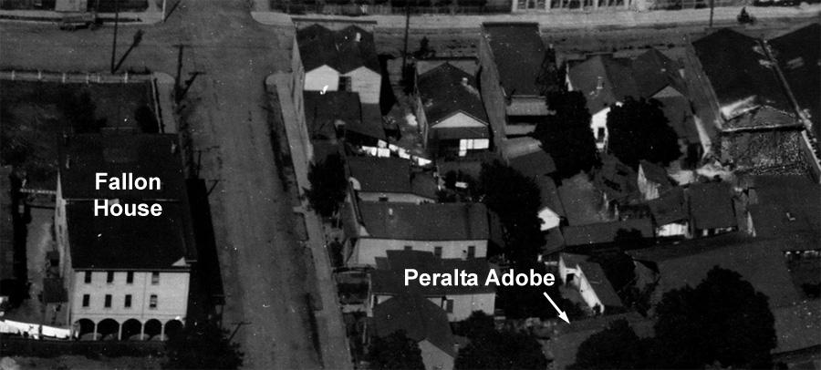
- across the street from the Fallon House is the Peralta Adobe, which you can
identify because it isn’t exactly perpendicular to the street, the roof line
is at a slight angle since the building was there before the street. There are
some more buildings to the right in the picture, at the same alignment as the
Peralta Adobe, but they aren’t there today.
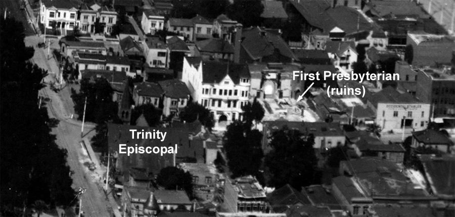
- on the right side of St. James Park, directly across the street from the park, is a church with a sharp pointed steeple. That’s Trinity Episcopalian Church, at the corner of St. John St. and Second St., still there today. It’s a wooden building and the oldest surviving church building in San Jose today, originally built in 1863 and altered at different times since then. On the other hand, going half a block to the right down Second St., on the far side of that street you see the ruins of a stone church, the First Presbyterian Church. The rear half of the church is still standing, but only the foundations are left of the front half of the church, which included the steeple. Again the quake wreckage has been efficiently removed within two months.
- all over the picture you can see washing hung out to dry on clothes lines.
No dryers, so the only way to dry clothes in quantity was the sun. You can tell
the Fallon House was probably still a private building, and not a commercial
building as after the later remodel, because of the clothes line and laundry
out in back. Sometimes you can begin to make out the individual pieces of clothing
on the clotheslines.
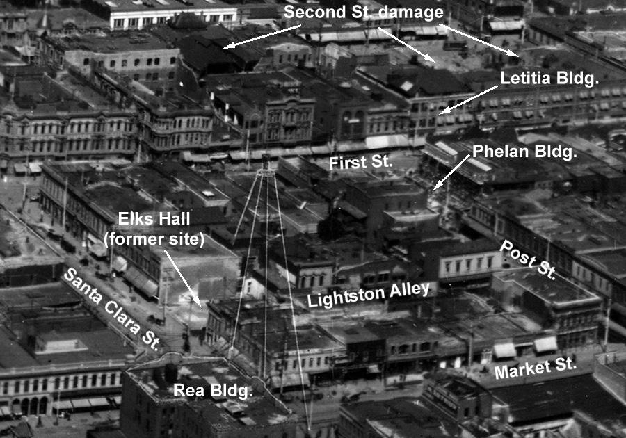
- moving over to the right from St. James Park, we’re in the downtown area. The most distinctive landmark here is the Electric Tower, at Santa Clara and Market St., built to illuminate whole blocks around. It appears in this picture outlined in thin white lines, because the outline was traced on the negative, so that people viewing the picture could make out the Electric Tower. It was a landmark, and purchasers of the photo would want to be sure to see it, not just a faint outline of the steel beams.
- also outlined on the negative is the top story of the Rea Building, on the near side of that same intersection. That was the tallest building downtown, so perhaps worth extra attention on the negative. It was originally a 3 story building, the Masonic and Odd Fellows building, built in 1865, but damaged in the 1868 earthquake. It was then repaired as an office building and called the Hensley Block. In 1880 a Gilroy farmer, Thomas Rea, bought it, and later he raised the roof and added two more stories on top under the raised roof. Today there’s just a more modern two story building at that corner, the San Jose National Bank headquarters.
- up Market St. from the Electric Tower, to the left in the photo (out of the detailed view above), there is a gap in the line of facing buildings over half way up the block. That’s not a parking lot or a construction site, that’s where the Saratoga boarding house occupied the second story above Williams Clothing store. The first story of the building failed in the quake, and the second story ended up at street level. A rude awakening for any boarding house guests. Wreckage of the complete building all cleared away, and seem the St. Charles Hotel, on the right side of the empty site, is open for business as usual.
- fire after the quake did the most damage in San Jose in 1906 on the west side of N. Second St. Looking here from behind the west side of that street, you can see gaps in the sequence of buildings, very different from the east side of N. Second St. where the buildings are all there, and all open for business.
- the Letitia Building survived the fires behind it on Second St. in 1906. This building also survived the downtown fire of 1892, when over 40 other buildings were destroyed, because rescuers slapped a ton of flour and water paste on the outside of the building and that was enough insulation to save it in 1892. The Letitia Building is still there today, with an extra story on the top.
- the Phelan Building, which housed Hobsons Clothiers, collapsed completely. Apparently some of the wreckage is still there in this picture, unusual since most wreckage was cleared very promptly. The adjacent building lost a wall, and perhaps that was a complication for removing the wreckage.
- the Elks Hall also collapsed completely, although here the wreckage is gone.
- you see many awnings throughout downtown, because
there was no air conditioning. Large glass storefronts would trap heat easily,
so shopkeepers relied on awnings outside to shade the windows. With the spread
of air conditioning, the need for awnings diminished. Now buildings are being
designed for energy conservation, and perhaps we will see more awnings again.
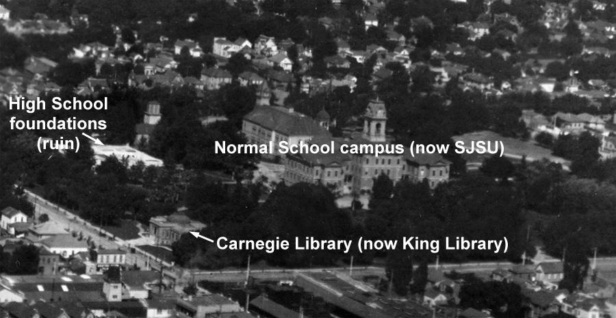
- above downtown is the wooded state San Jose Normal School campus, for teacher training, now San Jose State University. The central building with the tower survived the quake, but was damaged and torn down. The long classroom training building behind it survived until it was demolished in 1933. The small separate building at the front left corner of the campus is the 1903 Carnegie library, at Fourth and San Fernando, exactly where the new city and SJSU library building is today. The Carnegie library further east on Santa Clara St. today was built in 1908, after this picture, by the City of East San Jose, which later merged with San Jose.
- at the upper left corner of the SJSU campus, near San Fernando and Seventh, is a large white area among the trees. That was the site of San Jose High School, located on the Normal School campus for teacher training, which was destroyed in the earthquake when the top of the multi-story building collapsed into the bottom. Very fortunate that the quake didn’t hit in school hours. As you can see the wreckage has again been thoroughly cleared, less than 2 months later.
- two blocks further east, at Santa Clara and Ninth, there is
a church missing in the picture on the northwest corner. It was St. Patrick’s
Church, damaged in the quake and already demolished and removed when this picture
was taken, nothing visible. The congregation weren’t discouraged, and just
rebuilt on the same site.
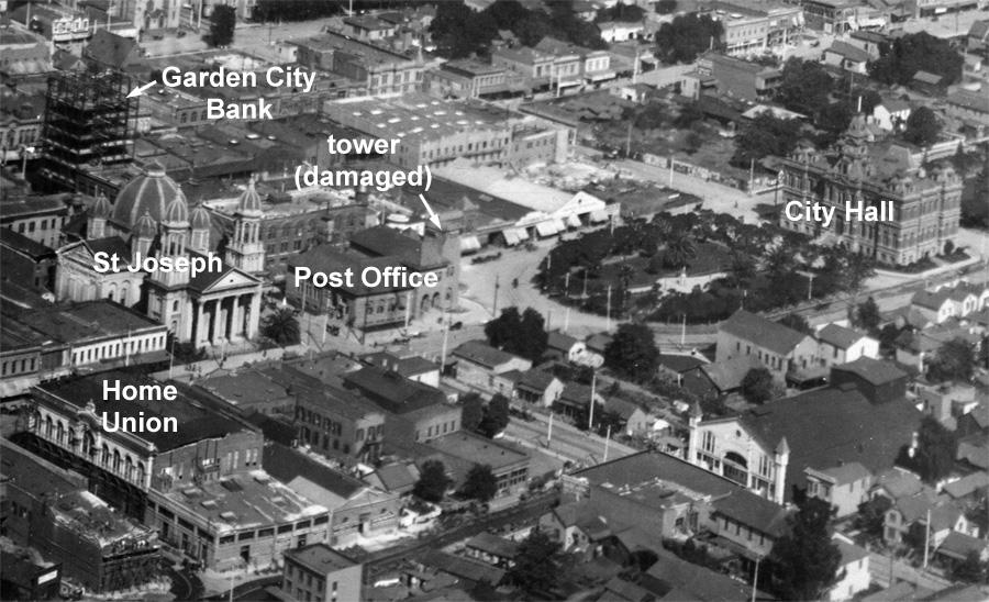
- below the campus is St. Joseph Cathedral, very prominent. It is the fourth church on this site: earthquakes damaged two previous churches, in 1822 and 1868 (1906 wasn’t the first major quake in San Jose), and fire destroyed a third, in 1875. To the right of the Cathedral is the Post Office, now the Museum of Art. You can see the gap where the Post Office tower collapsed in the 1906 quake.
- immediately behind the cathedral is the steel skeleton of the seven story Garden City Bank building at First and San Fernando, under construction. The building was completed after the earthquake, and it was San Jose’s first steel frame office building, first of many. In 1909 Charles Herrold made the first regular public radio broadcasts in the world from this new building, and he also broadcast the first radio advertising (see www.charlesherrold.org). The Knight Ridder building now occupies this site.
- straight down from the dome of St. Joseph is a large two story building at Market and Post St., with an ornate façade on Post St. This was the Home Union Building, and the equally ornate façade on Market St. simply peeled off during the quake, leaving all the front rooms in the building completely exposed.
- to the right of the Post Office (Art Museum) is the 1887 City Hall, sitting right in the middle of City Hall Plaza (now Cesar Chavez Plaza). The plaza around it certainly helped to set off this building, as you can see. This plaza is where the California Statehouse stood in 1850, when San Jose was the state capital.