Notes on George Lawrence's 1906 Aerial Panoramas
of Santa Cruz, California
by Peter NurkseJanuary 2011
PDF version
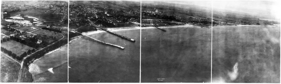
This panorama of Santa Cruz in the summer of 1906 seems to have some insight into the spirit of the place. It is not a typical promotional or resort picture of sun and surf, as you can see from the overcast sky and the mist in the air. It shows a small community captured between the mountains and the curve of the ocean. The ocean itself takes up about half of the picture, emphasizing the natural environment of Santa Cruz. It could be called a profound picture of Santa Cruz, because it shows Santa Cruz as people who live here know it, as a smaller community, somewhat isolated and different too, with some characteristic depth and feeling. Almost like a portrait of a person, but capturing a community.
In 1906 ocean front property wasn't yet crowded real estate. Most people chose to live near each other and near services and other supplies, closer to downtown. It is sobering to think that the people who lived in this landscape probably took what we see here as quite stable and settled, the way things were. Yet less than a century later, much has changed. So what we take for granted today may also look very different in another century. And changes can happen in cycles: over a century people moved into downtown, then they moved out, then they moved back again, so perhaps that cycle will just continue.
Below are some comments on buildings and places in the photo. Most of my background on the two wharves and the pier is from Ross Eric Gibson, who also had information on other buildings and properties. John Chase’s "Sidewalk Companion to Santa Cruz Architecture" was a source of information on other buildings in the picture. And Bonnie Minford, the Boardwalk historian, researched archive records there to help fix the date of the photograph as June 24, 1906, the day before they started to lay down a temporary new floor on the charred pilings of the old Casino building that had burned down only two days before.
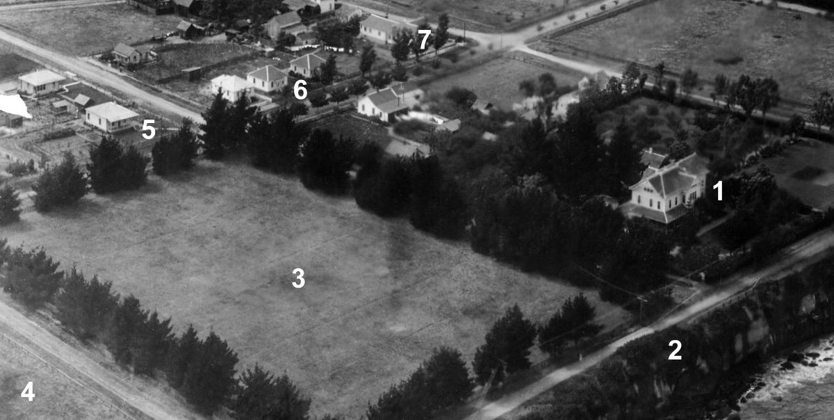
1. Epworth-by-the-Sea: large house built in 1887, once owned by Bishop Warren, a Methodist Bishop, and well preserved today. Small cottage right behind, with a chimney, has also survived intact.
2. West Cliff Drive: clearly built as close as possible to the cliff edge here, probably without thought for future coastal erosion.
3. Hearst Grove: rectangular grove of trees, owned by Phoebe Apperson Hearst, mother of William Randolph Hearst (newspaper publisher). She never built on this property, and instead donated the first building, the Administration building, at the Asilomar conference center in Pacific Grove in 1913.
4. Cliff Manor: land owned by William Dingee, who developed the cement plant in Davenport and was known as the Cement King. Although there was an increased demand for cement after the quake Dingee had financial problems, and wasn’t able to build a planned home on this property.
5. 421 Lighthouse Ave.: may be under construction in this picture, roof seems new, perhaps not finished yet. House next to it on Monterey St. is gone today.
6. 507 and 511 Lighthouse Ave.: pair of twin houses still there today.
7. 523 Lighthouse Ave.: longer corner house, front of house obscured in photo by a tree no longer there. Vacant lot between 511 and 523 Lighthouse Ave. is still a vacant lot today, has survived over a century.
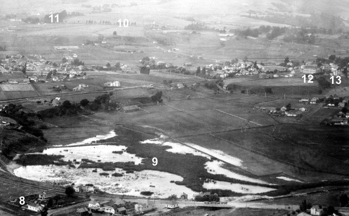
8. 603 Laguna St.: one story here, but today two stories with a ground floor added beneath.
9. Neary's Lagoon: very much a lagoon, in its wild state then, but also some areas to the right fenced and drained for pasture. Today the city sewage plant occupies the natural part of the lagoon in the picture, and the natural lagoon of today has been reclaimed from the pastureland in the picture.
10. High St.: a line of trees marks gradual ascent of High St., toward the Cowell Ranch to the left.
11. Cowell Ranch House: within the grove of trees on High St., and now the Cardiff House at UCSC. The current UCSC main entrance is to the left of this grove. If anyone in 1906 had suggested putting 20,000 people here, with only the same two streets for access as in 1906 (High St. and Bay St.), they probably would have been laughed out of town.
12. High School: the old wooden High School building, with a tower, which burned down in 1914.
13. Thomas Weeks House: large residence with a pointed turret, to the right of the high school, covered with ornate wooden trim. When the high school was rebuilt in 1915, the house was moved several blocks to its present location at 724 California St. Houses could be moved about in Santa Cruz during this period, and present locations may be different.
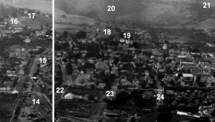
14. Railroad Yard: for over a century this was a working railroad yard, and is now a city park, Depot Park. Note the steam plume from an engine heading out of the yard north towards Felton. As now, the railroad tracks north pass up Chestnut St.
15. Lincoln St. Houses: four of the five row houses at 412 - 420 Lincoln St. are visible.
16. Highland Ave.: steep diagonal slash traces Highland Ave. up the hill, following the route of the present pedestrian path. Modern Highland Ave. takes an easier path and zigzags up the hill with a switchback.
17. Judge Logan's House: about 1880 Judge James H. Logan developed the Loganberry here, which was later crossed with other plants to create the Olallieberry and the Boysenberry. Like many large Victorians, the house later fell into neglect and was torn down in the 1940’s.
18. Holy Cross Church: very faint in this picture, may be difficult to see unless zoomed in close on a computer monitor. It appears faint, almost a spiritual presence in the picture. Because in 1906 it wasn’t painted a distinctive white color, as it is today, but instead it was the original raw unpainted brick. And raw brick doesn’t reflect light as well as a white surface.
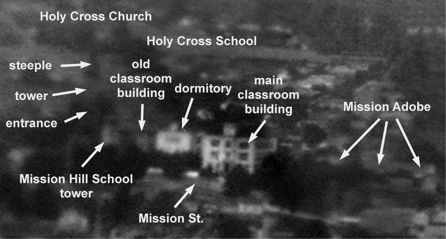
In front of the church in this view is Mission Hill School, and the original building on this site was the first public school in Santa Cruz. Here we can see only the tower on top of the school building. Both the tower and the entire top floor (site of first high school in Santa Cruz) were removed later in 1906 because of earthquake damage. In 1931 a new school was built at the present site on King St., and this location was later used for a school administration building.
19. Holy Cross School: Holy Cross was much more visible then on Mission Hill than the Holy Cross School of today. The wooden old classroom building was originally in the center of the campus, and was later moved over to the Mission Plaza side, to make room for the dormitory and the new classroom building. All these buildings are now gone. To the right of Holy Cross School is the long horizontal roof of the original Mission Adobe building, restored now, shorter, as a state park. The building seems quite a different architectural style than the other buildings in the panorama, it is more subdued, long and low to the ground, a presence from another culture in a different period a century before 1906.
20. San Lorenzo Valley: the canyon of the San Lorenzo river.
21. Pasatiempo: broad hill side, site of golf course and Pasatiempo development.
22. Washington St.
23. Center St.
24. Cedar St.
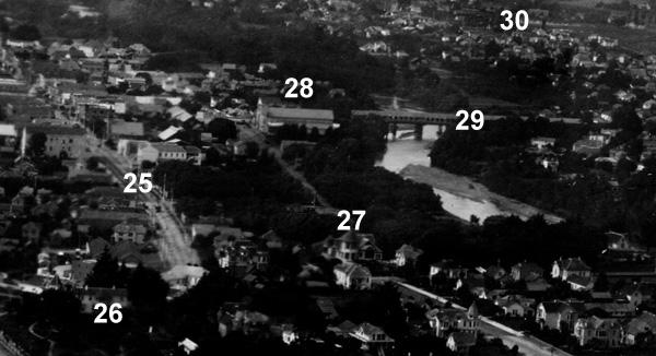
25. Pacific Ave.: only the lower end of the street is visible in this picture, but you can see how the buildings line both sides of the street further up. Street trolley tracks along the street, and at least one trolley car. Cedar and Center and Washington streets are all visible one after another to the left of Pacific Ave.
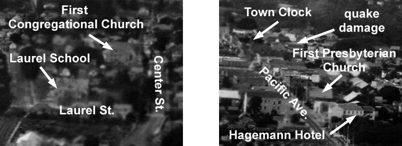
The First Congregational Church was at the corner of Center St. and Lincoln St., now the location of the Santa Cruz Boys and Girls Club, before it moved to the present High St. location in 1958. Laurel School was an imposing three story building, with a tower, before it was replaced by a new school building in 1931, now the Louden Nelson Community Center.
The Hagemann Hotel is easy to identify from the 1905 edition of the Sanborn fire insurance maps, including details such as the outside staircase in the back. The Santa Cruz public library has a set of Sanborn maps, and all Sanborn maps for all cities and towns in California, from 1867 to 1970, is available on-line for download and printing from the San Francisco public library website (go to http://sfpl.org/sfplonline/dbcategories.htm, then to the History & Genealogy heading, and select "Sanborn Maps California"). You do need a S.F. library card, which can be obtained at any library branch in San Francisco.
The First Presbyterian Church has moved on to the corner of Mission St. and Highland Ave,, and the Town Clock is now standing by itself at the top end of Pacific Ave. Some earthquake damage to the roof is visible in the area of the old County Courthouse. It was substantially damaged in the 1906 quake, but was repaired and survived on, most recently as the Cooper House, until the 1989 quake.
26. Sunshine Villa: the home of James Smith, who starting in 1895 helped promote an annual Venetian Water Carnival on the San Lorenzo river. Later the building became the McCray hotel, and inspired the setting for the Bates mansion in Hitchcock’s movie Psycho. Today it is called Sunshine Villa again, an assisted living retirement center.
27. Golden Gate Villa: distinctive large corner tower, and well preserved today at 924 Third Street, on Beach Hill.
28. Chinatown: the old Chinatown was located between Pacific Ave. and the river, on the far side of the bridge. The large building on this side of the bridge is a Naval Armory.
29. Soquel St. Bridge: a covered bridge, the roof is a lighter color. Wooden bridges were covered to help reduce maintenance. This bridge was built high, to clear floods. After the river was channeled in the 1950’s, bridges were built lower. But then the Corps of Engineers decided there was still a flood danger, and bridges were built higher again.
30. Branciforte: one of only three pueblos, or towns, in colonial California. The oldest home still in use in Santa Cruz is an adobe building at the north end of Branciforte Ave. The residents of Branciforte were apparently mostly exconvicts, who used Branciforte Ave. as a horse racing track, to the scandal of the missionaries across the river. Perhaps that's why their settlement never quite rivaled San Jose or Los Angeles, the other two pueblos.
31. Lynch House: built by Sedgwick J. Lynch, an early Santa Cruz builder, at 174 West Cliff Dr. Described as "the finest residence in Santa Cruz" when it was built in 1877, and now restored as a bed-and-breakfast. Apparently it always stood alone, separated from other homes.
32. West Cliff RR Overpass: was a working bridge in 1906, then rebuilt after the 1989 earthquake and now in use again.
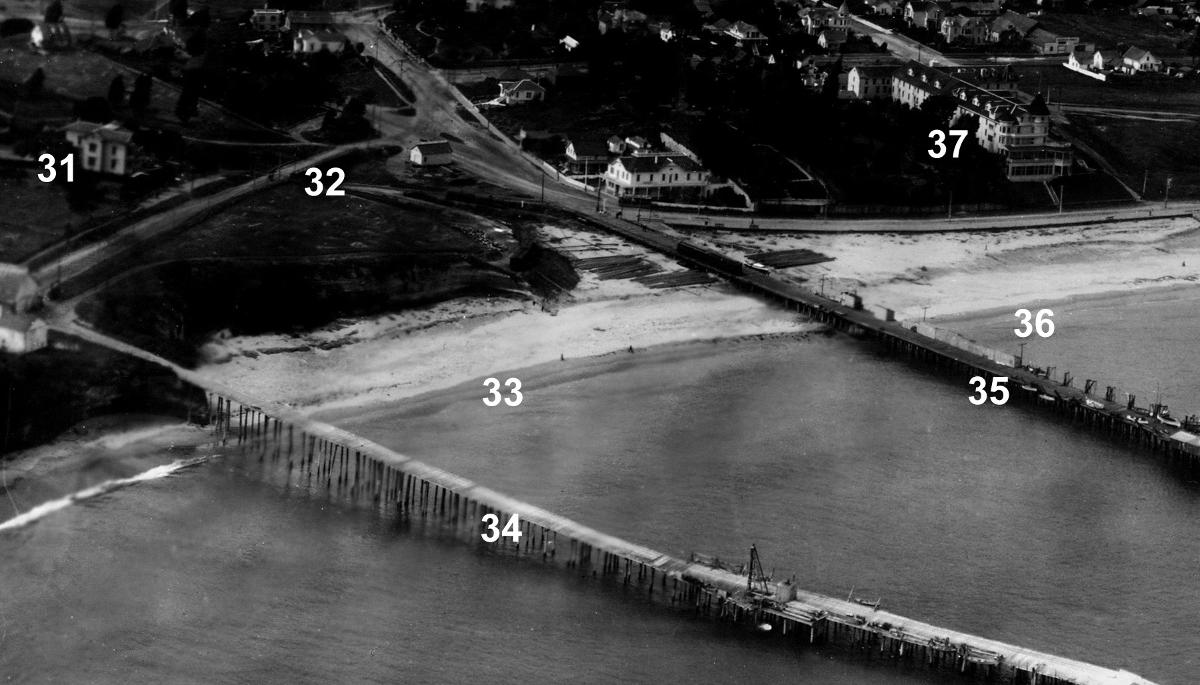
33. Cowell Beach: perhaps got its name from Cowell Wharf next to it.
34. Jordan and Davis Wharf (later Cowell Wharf): the first wharf in Santa Cruz, originally built at this location by Elihu Anthony in 1849. In 1906 it was owned by the Henry Cowell Limeworks, but broke into two parts in a storm a year later, at the end of 1907. The pier is an extension of Bay St., which was an important commercial route, to avoid hauling lumber, lime, and other heavy cargo through downtown. In this picture you can see a wagon train, with pairs of horses pulling two large wagons, crossing the small bridge on Bay St. in front of the lagoon, heading to the wharf.
35. Railroad Wharf: David Gharkey built this wharf in 1856, which became the Railroad Wharf after the South Pacific Coast Railroad bought it in 1875. The railroad tracks ran all the way out to the end of the wharf, which was torn down in 1922.
36. Municipal Wharf site: the city built the present Municipal Wharf here in 1914, just east of the Railroad Wharf, because the Southern Pacific had decided to stop maintaining the Railroad Wharf.
37. Sea Beach Hotel: a first class hotel, like the Del Monte in Monterey. And a fine location, right on the bay, but it burned down to the ground six years later, on June 12th, 1912. Ever since then, for an entire century, the question has been raised regularly whether Santa Cruz needs another first class hotel.
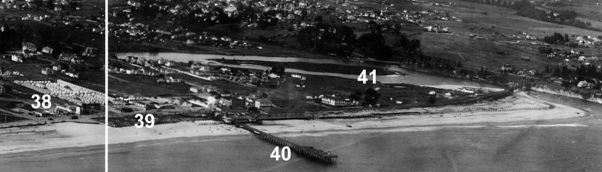
38. Tent City: rows of tent cabins, on wooden floors, built to house visitors. This was the last year of the tent cabins, and in 1907 they were replaced by simple wooden cottages. Along Beach St. there were various heated saltwater bath houses, where visitors could enjoy the health benefits of bathing in saltwater without going into the chilly ocean.
39. Boardwalk Casino site: the old Boardwalk Casino building, a wooden building with turrets in Moorish style, burned down on June 22, 1906, together with the seawater Plunge pool building next door. But already on June 25 all the wreckage had been cleared, and work began that day on a new wooden floor on top of the pilings of the old Casino. On June 30, less than a week later, the Boardwalk began erecting a tent over that floor to use as a temporary structure for the summer. Here you can see the blackened charred pilings of the old casino foundations along the beach edge. And on the right side of that charred area is a bright shining feature, which is the concrete Plunge swimming pool, it survived the fire even thought the Plunge building also burned down to the pilings. So probably the picture was taken on June 24, 1906, when they’d cleared the wreckage but before they started putting down the new Casino floor. And perhaps George Lawrence was motivated to come over to Santa Cruz by the news of the Casino fire, just as the S.F. earthquake and fire brought him out from Chicago.
40. Pleasure Pier: built in 1904 to carry seawater to the indoor pool in the plunge building. First called the Electric Pier, because it was lighted at night, it was demolished in 1965, when the plunge was converted to a miniature golf course.
41. San Lorenzo River: the river is in its original natural state, meandering through the town, before the Corps of Engineers channeled it in the 1950’s. The island near the river mouth was called Opera Island, and was used to stage performances for audiences on the river banks. The wooden railroad bridge at the river mouth was later rebuilt as a steel bridge.
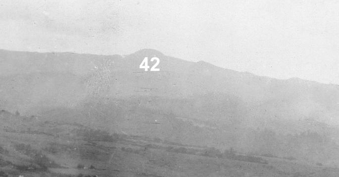
42. Loma Prieta: distinctive outline of this peak hasn’t changed. Bare clear cut hills everywhere in the picture, after the first wave of logging in the mountains.
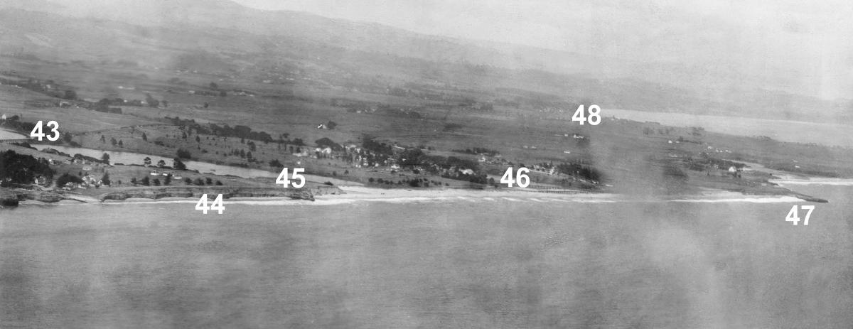
43. Eaton Ave. Bridge: railroad bridge, but older than the present steel bridge.
44. Seacliff Beach: a very narrow strip of beach in 1906, and neighborhood inland quite undeveloped. The present yacht harbor jetty has added much more sand.
45. Yacht Harbor: just a lagoon back then, Wood’s Lagoon.
46. Schwan Lake: now part of Twin Lakes State Beach. You can see the streetcar trestle by the ocean, as well as a railroad trestle further inland. The pilings of the streetcar trestle can be seen now often at low tides off Twin Lakes beach.
47. Black’s Point: small rocky point. On this side of the point is Black’s Beach, located today at the end of 13th Ave.
48. Capitola: town itself not visible, but at the same location on the coastline today.